1
/
of
1
Waterproof charts
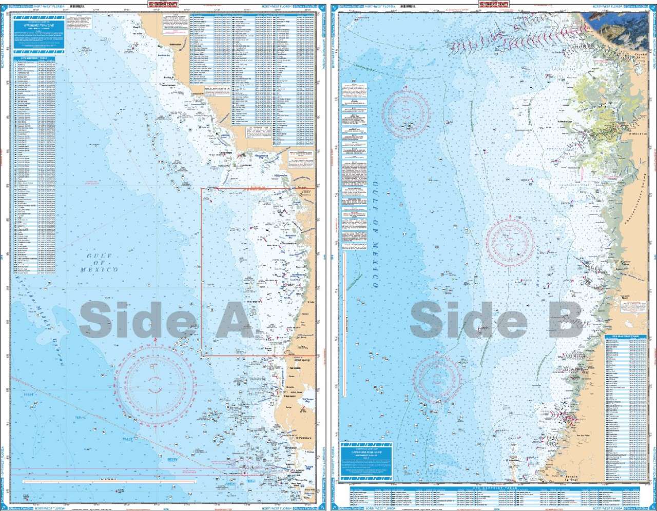
Florida Waterproof Charts – Offshore Fish & Dive
Florida Waterproof Charts – Offshore Fish & Dive
1.0 / 5.0
(0) 0 total reviews
Regular price
$26.95
Regular price
Sale price
$26.95
Unit price
/
per
Shipping calculated at checkout.
Couldn't load pickup availability
SKU:5F
Description:
Offshore coverage from Steinhatchee River south to Anna Maria Island and out to the Florida Middle Grounds (100 miles). Coastal Coverage on reverse side from Port Inglis south to Anclote River. 184 Plotted and Indexed GPS Positions with descriptions for Reefs, Wrecks, Ledges and Markers. Enhanced Contour Lines. Information from 2 NOAA Charts: 11409 & 11400. GPS Datum. 25" x 38"
SKU: 6F
Description:
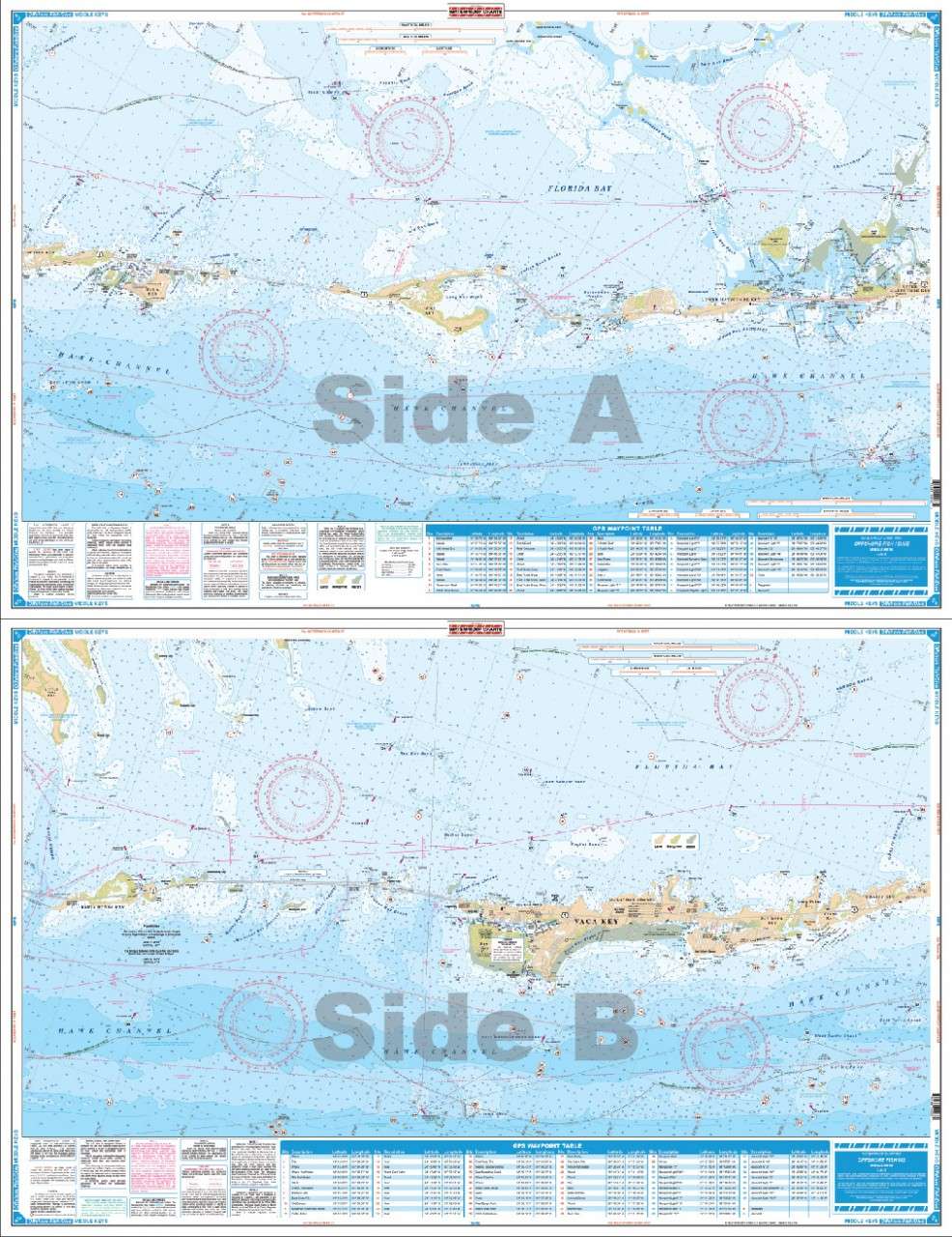
Coverage from "Bud & Mary's" on Upper Matecumbe Key west to Bahia Honda Key - offshore to the reef (60' curve), and approximately 4 miles into Florida Bay. Great detail of Marathon and Boot Key Harbor. Complete ICW and Hawk Channel Routes. 88 Plotted and Indexed positions for reefs, wrecks, lights, fishing, and diving sites. Information from NOAA 11449. GPS Datum. 25" x 38"
SKU: 7F
Description:
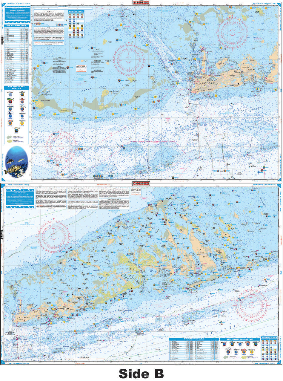
Coverage from the 7-Mile Bridge west to Boca Grande Key and Woman Key (10 miles west of Key West). Offshore to the Reef and north to The Content Keys and Turtlecrawl Bank. West Side is detailed coverage of Key West Area. 80 Plotted and Indexed GPS Positions for reefs, wrecks, lights, fishing and diving sites. Information from 2 NOAA charts: 11441 & 11442.GPS Datum. 25" x 38"
SKU: 8F
Description:
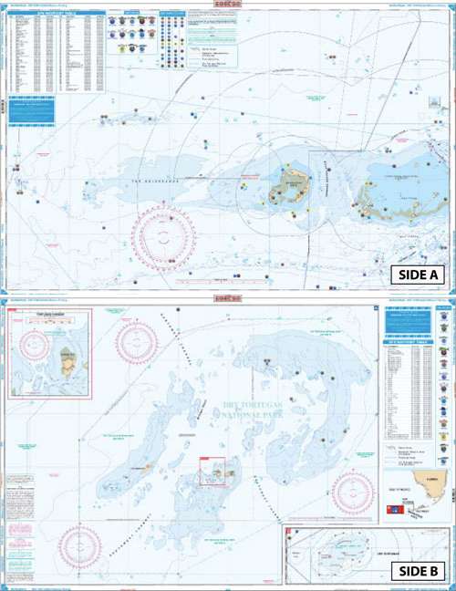
Coverage from Sand Key and the Northwest Channel (west of Key West) west to Rebecca Shoal on the east side. Offshore inset on west side shows passage from Rebecca to the Tortugas. Detailed coverage of the Dry Tortugas on west side with blow up of Tortugas Harbor and Fort Jefferson. 187 Plotted and Indexed GPS Positions for reefs and wrecks, lights, fishing and diving sites. Added color highlights shallow areas and enhanced contour line defines 60' curves. Information from 3 NOAA Charts: 11439, 1438, 11434. GPS Datum. 25" x 38"
SKU: 9F
Description:
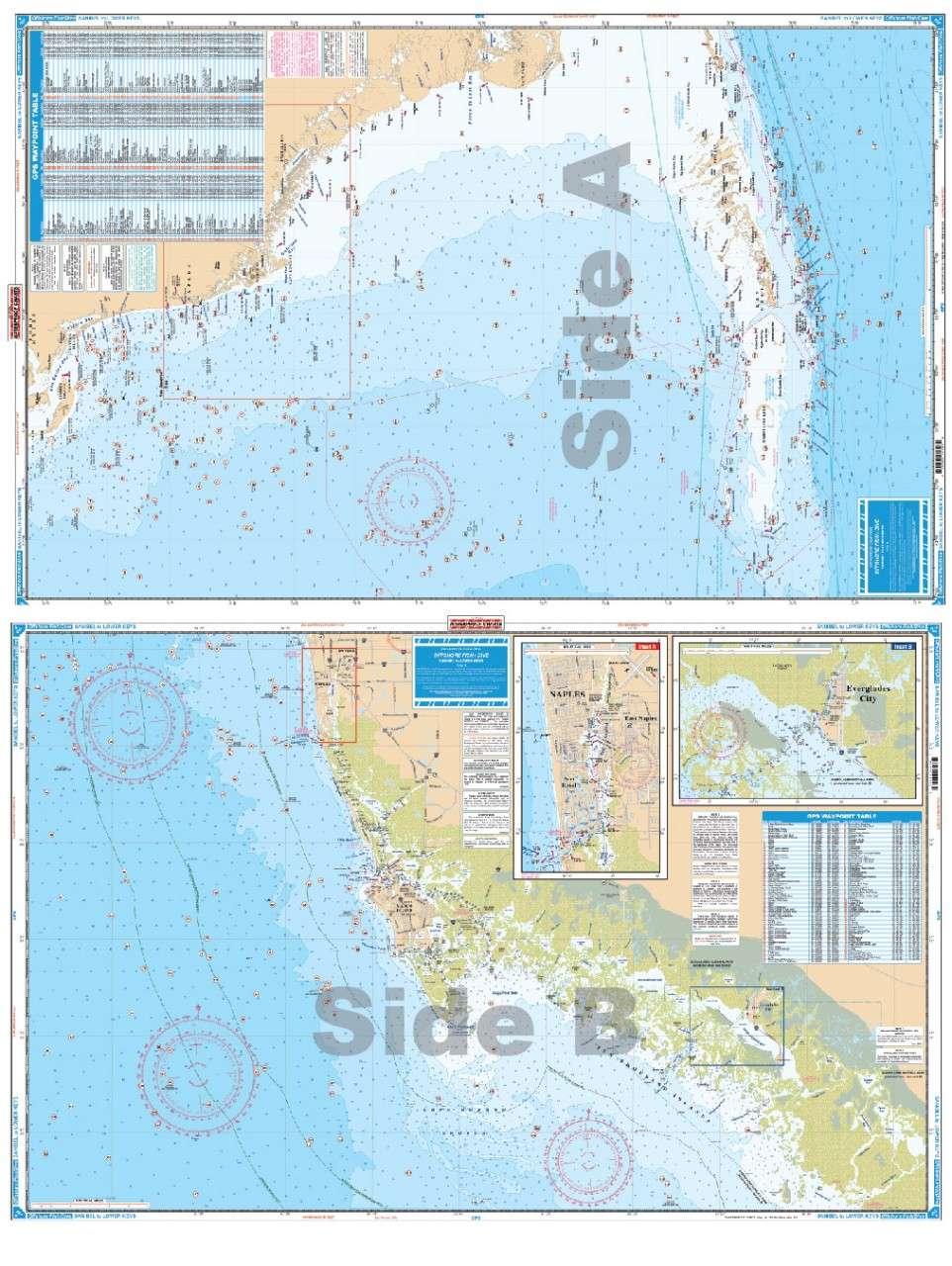
Offshore Coverage from Sanibel south to 20 miles south of Key West, east to Marathon and west to 82 degrees 40 minutes (Rebecca Shoal). Reverse Side is Coastal Coverage of Naples south to Pavillion Key offshore to 82 degrees 5 minutes. Details for Naples - Gordon River and Everglades City. A total of 369 Plotted and Indexed GPS Positions for reefs, wrecks, lights, fishing and diving locations. Information from 2 NOAA charts: 11429 and 11420. GPS Datum. 25" x 38"
SKU: 10F
Description:
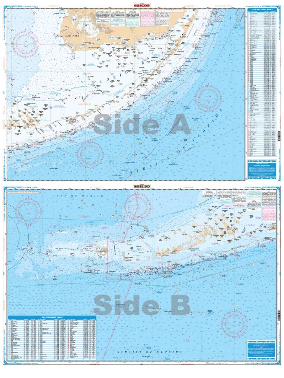
Offshore coverage from Rebecca Shoal (west of Key West) to North of Key Largo. Shows depths from the reef out to 500 fathoms and sections of the Gulf to north of Cape Sable. Does not show detail inside the reef or in east Florida Bay nor close to the Keys. Bathymetric contours have been added in popular fishing areas and peaks and holes have been highlighted.A total of 200 Plotted and Indexed GPS Positions for reefs and wrecks, fishing areas such as the "Hump", "Woods Wall", and the "Ups and Downs." Information from 2 NOAA Charts: 11434 and 11450. GPS Datum, 25" x 38"
SKU: 14F
Description:
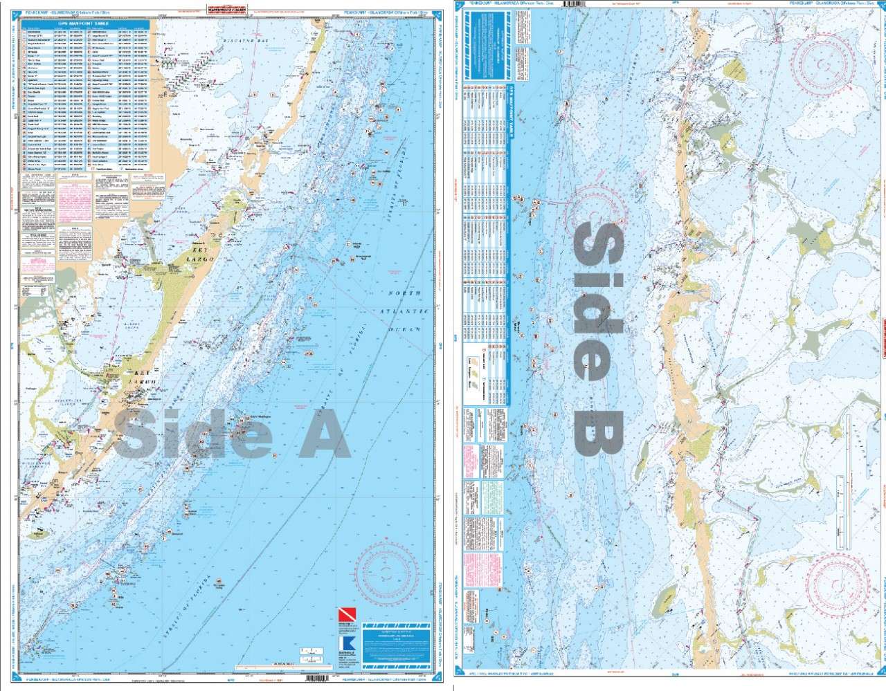
Completely redone in 2011 with coverage from Turkey Point in Biscayne Bay south to Lower Matecumbe Key. Detailed coverage of both Atlantic and Florida Bay sides of the Keys. Complete coverage of Card Sound, Barnes Sound and Blackwater Sound and Pennekamp Coral Reef Park. Complete ICW coverage to Bowlegs Cut.Florida Bay covered only approximately 5 miles north and west of the Keys. (For complete Florida Bay coverage see # 33 or #33E). Highlighted Park Boundary Lines. A total of 88 Plotted and Indexed GPS Positions for Reefs, Wrecks, Lights and Fishing and Diving Locations. Large Print is very easy to read. Information from 4 NOAA charts: 11463, 11449, 11451, & 11462. GPSDatum. 25" x 38
SKU: 15F
Description:
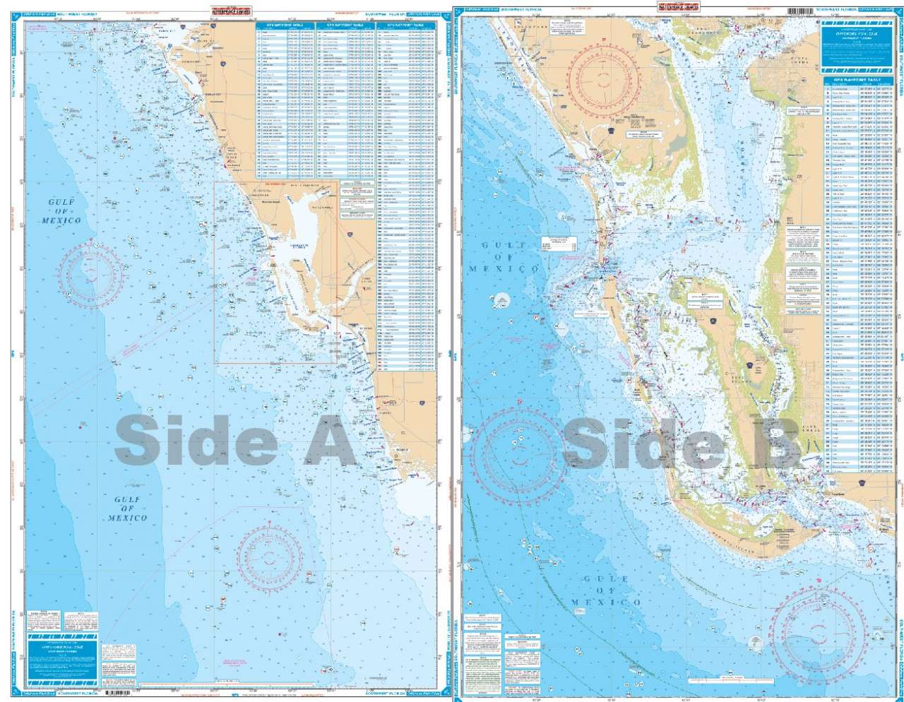
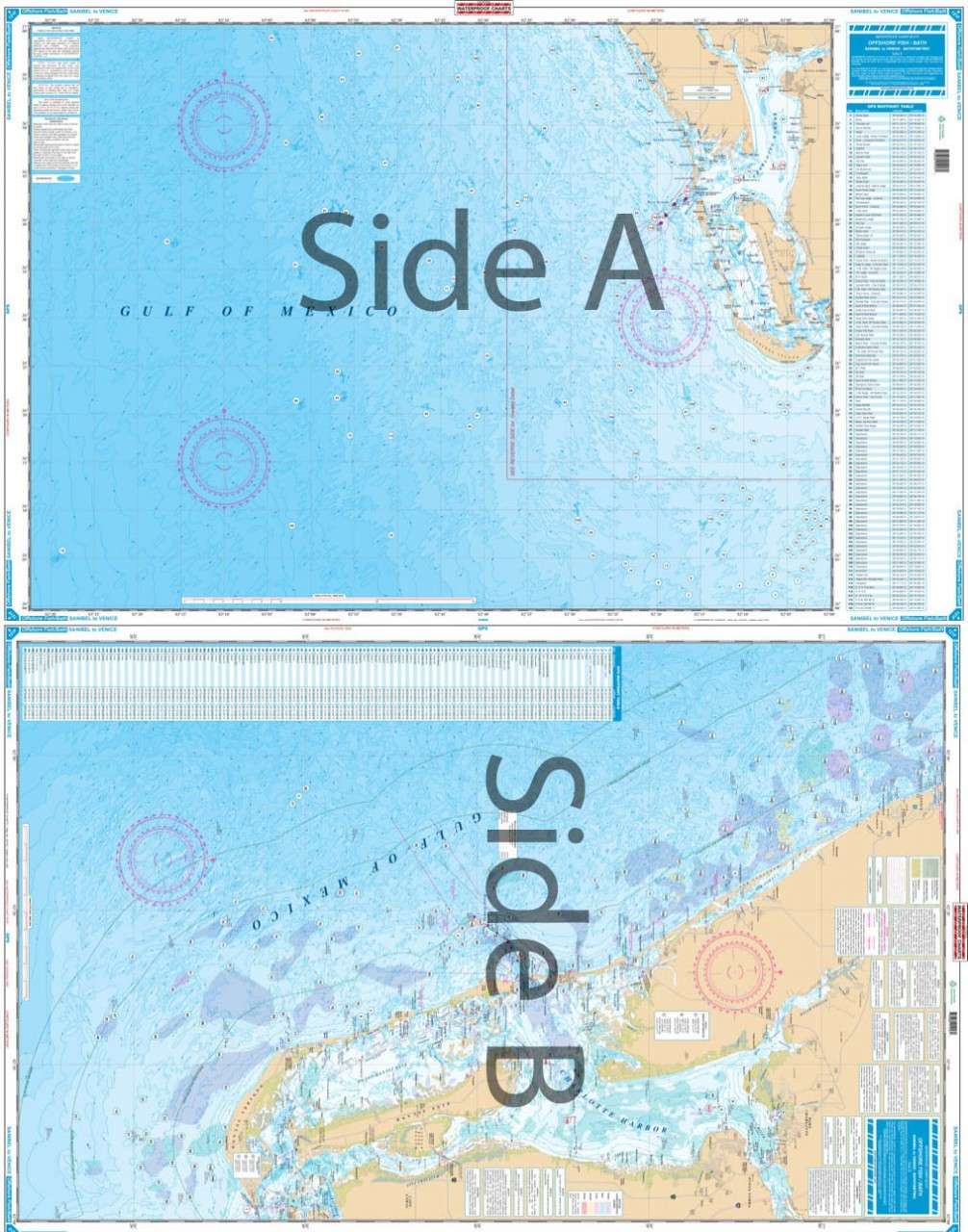
Complete offshore coverage from Tampa Bay south to 50 Miles South of Marco Island. Reverse side is coastal coverage from Englewood south to Ft. Myers Beach with complete depths for Charlotte Harbor, Pine Island Sound, and Matlacha Pass.A total of 369 plotted and indexed GPS Waypoints for reefs and wrecks, lights, and fishing and diving areas. Information from 2 NOAA Charts: 11426 & 11420. 25" x 38"
SKU: 18F
Description:
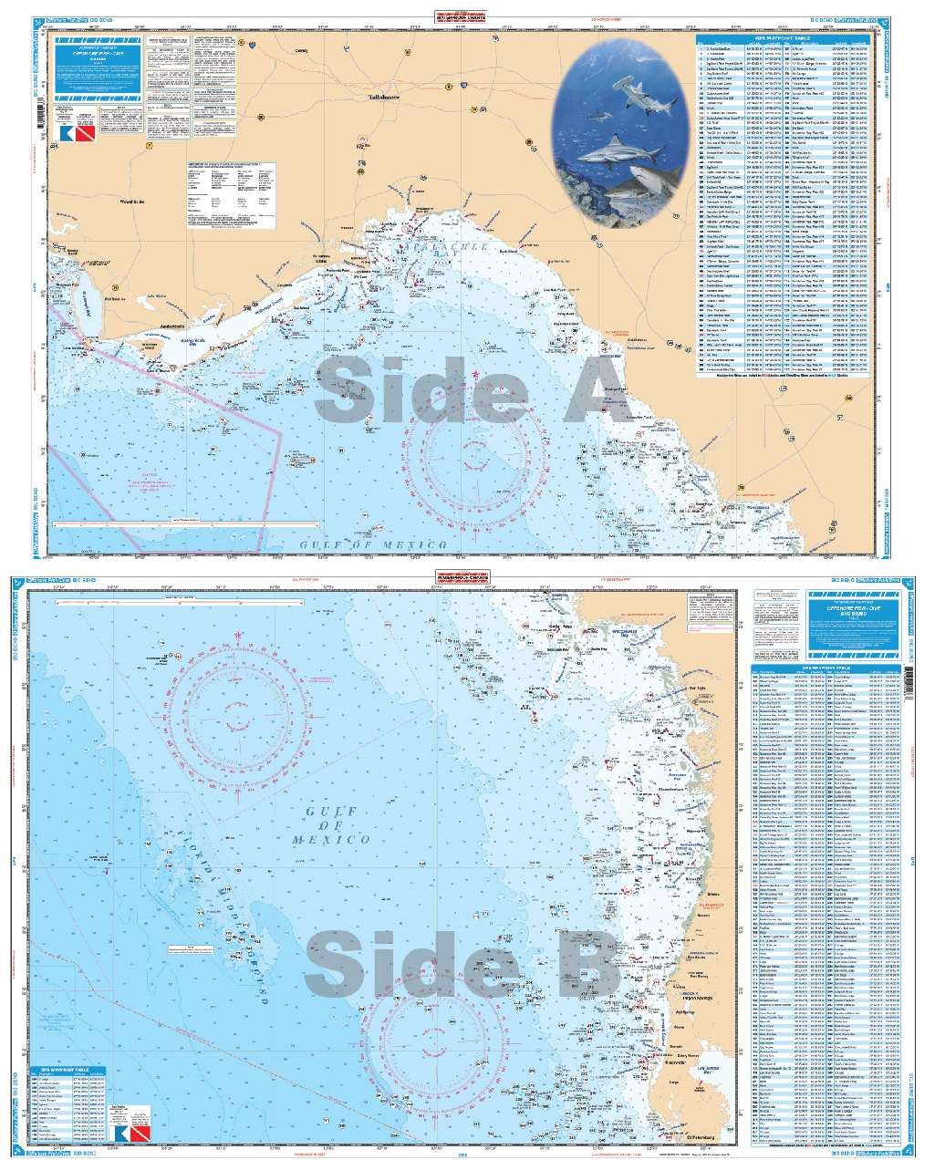
Covers the area from Port Inglis around the Big Bend just West of Apalachicola to Cape San Blas. 25" x 38"
SKU: 19F
Description:
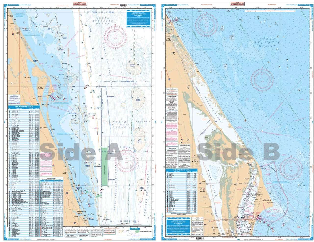
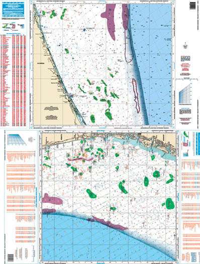
Coastal coverage from Cape Canaveral south to Jupiter and offshore to a maximum of 32 miles. Large Place Names make towns easy to find. A total of 211 Plotted and Indexed GPS Waypoints for reefs and wrecks, lights, fishing and diving areas. Information from 2 NOAA Charts: 11474 & 11476. 25" x 38"
SKU: 23F
Description:
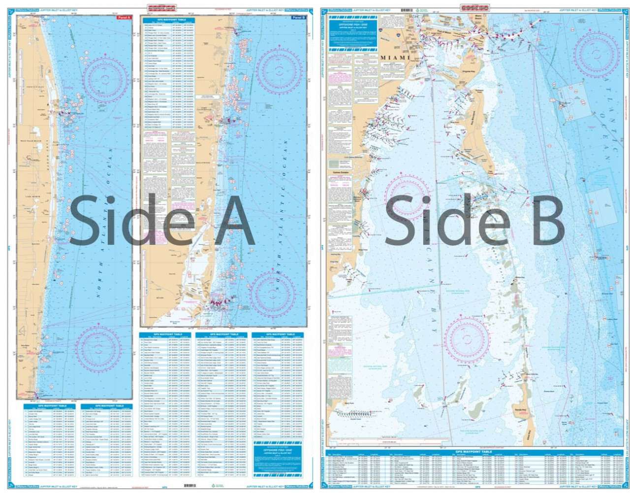
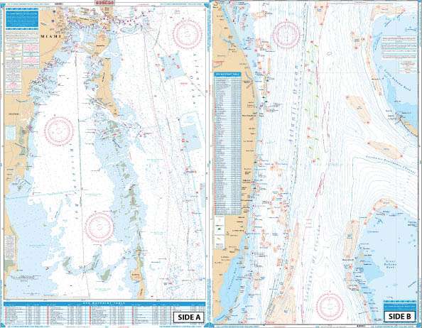
Coastal coverage from Jupiter south past Palm Beach, Ft. Lauderdale, and Miami to Elliot Key. Detail of South Biscayne Bay from Government Cut to Black Point and Sands Key. Coverage is up to 10 miles offshore and does not include ICW detail north of Government Cut. (see 23 for ICW detail). A total of 280 plotted and indexed GPS Waypoints for reefs, wrecks, lights, buoys, fishing, and diving areas, including the entire Dade-Broward Artificial Reef Program. Information from 2 NOAA Charts: 11465 & 11466. 25" x 38"
SKU: 94F
Description:
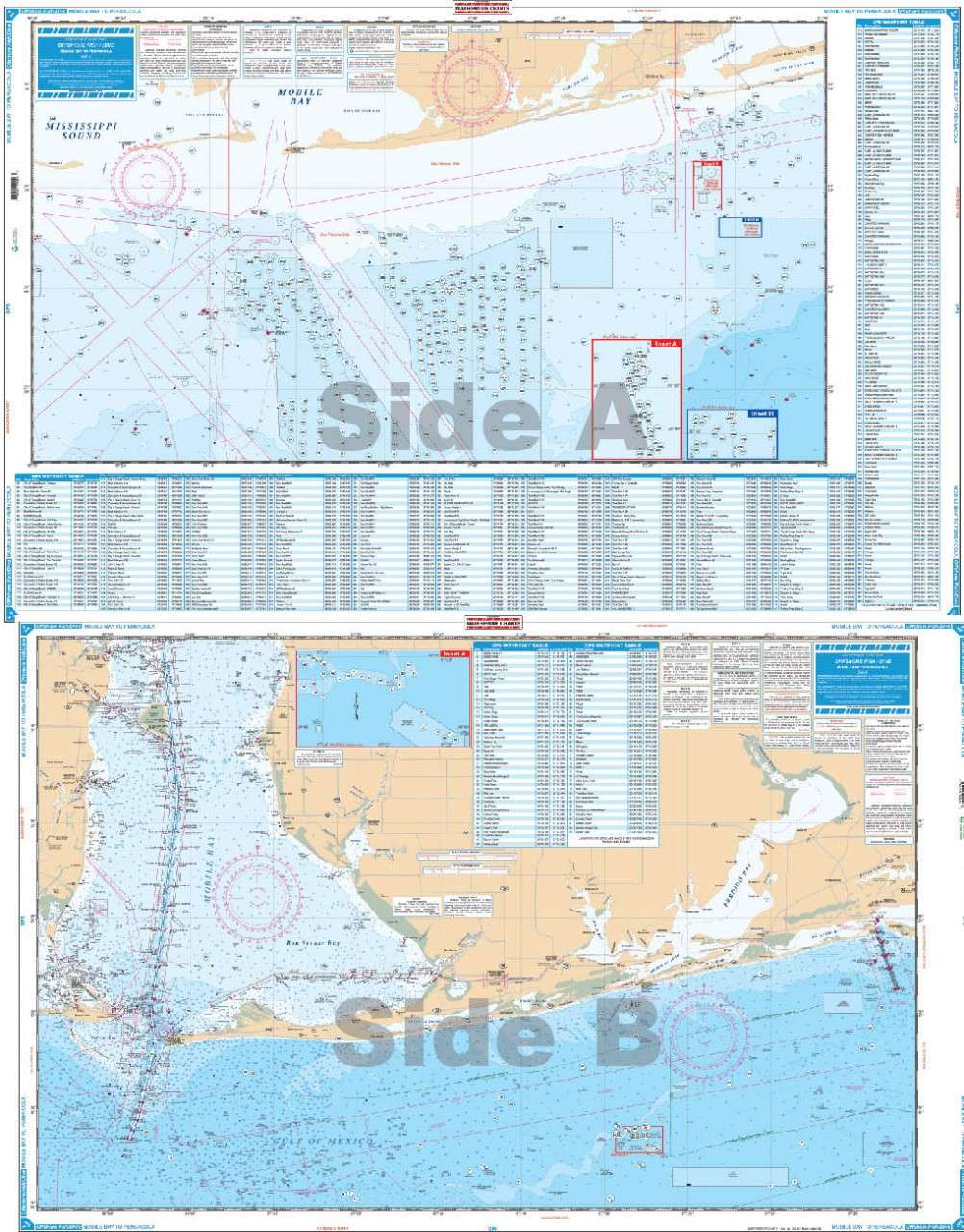
Offshore coverage from Dauphin Island, Alabama to Pensacola Beach Florida out 30 plus miles. This chart is a compilation of 3 NOAA charts # 11360, 11376 and 11382.This chart goes up into MOBILE BAY over 21 miles, and offshore over 30 miles. From Daupin Island the chart goes over 55 miles to the South.The chart has over 550 plotted and indexed GPS waypoints for wrecks, reefballs, ledges and artificial reefs, fishing and diving locations. The really unique feature to this Offshore Fishing Chart is that it is LARGE PRINT!!! Meaning it is much easier to see the coordinates of your favorite fishing destination. No one has a chart like this. If you want to enjoy all of the State, County and private fishing locations in this area , you MUST have this Waterproof Offshore Fishing Chart #94F. If you want ORANGE BEACH , Alabama, you want this chart. 25" x 38"
SKU: 95F
Description:
One side has offshore coverage from 10 miles south of Charleston to north of Morehead City and out past the 100 fathom curve. The reverse side details the Cape Fear and Frying Pan Shoals area north past Wrightsville Beach to New Topsail Inlet. Both sides have colored overlays which detail hardgrounds and live bottom areas indexed to GPS coordinates.The offshore side has additional bottom contours for the drop of area between 30 and 100 fathoms, detailing areas such as "The Steeples, "the Georgetown Hole," "Big Rock," and "Sanctuary." A total of 361 GPS Waypoints for wrecks, lights, and fishing sites. Information from 3 NOAA charts: 11536, 11539, 11520. GPS Datum. 25" x 38"
SKU: 99F
Description:
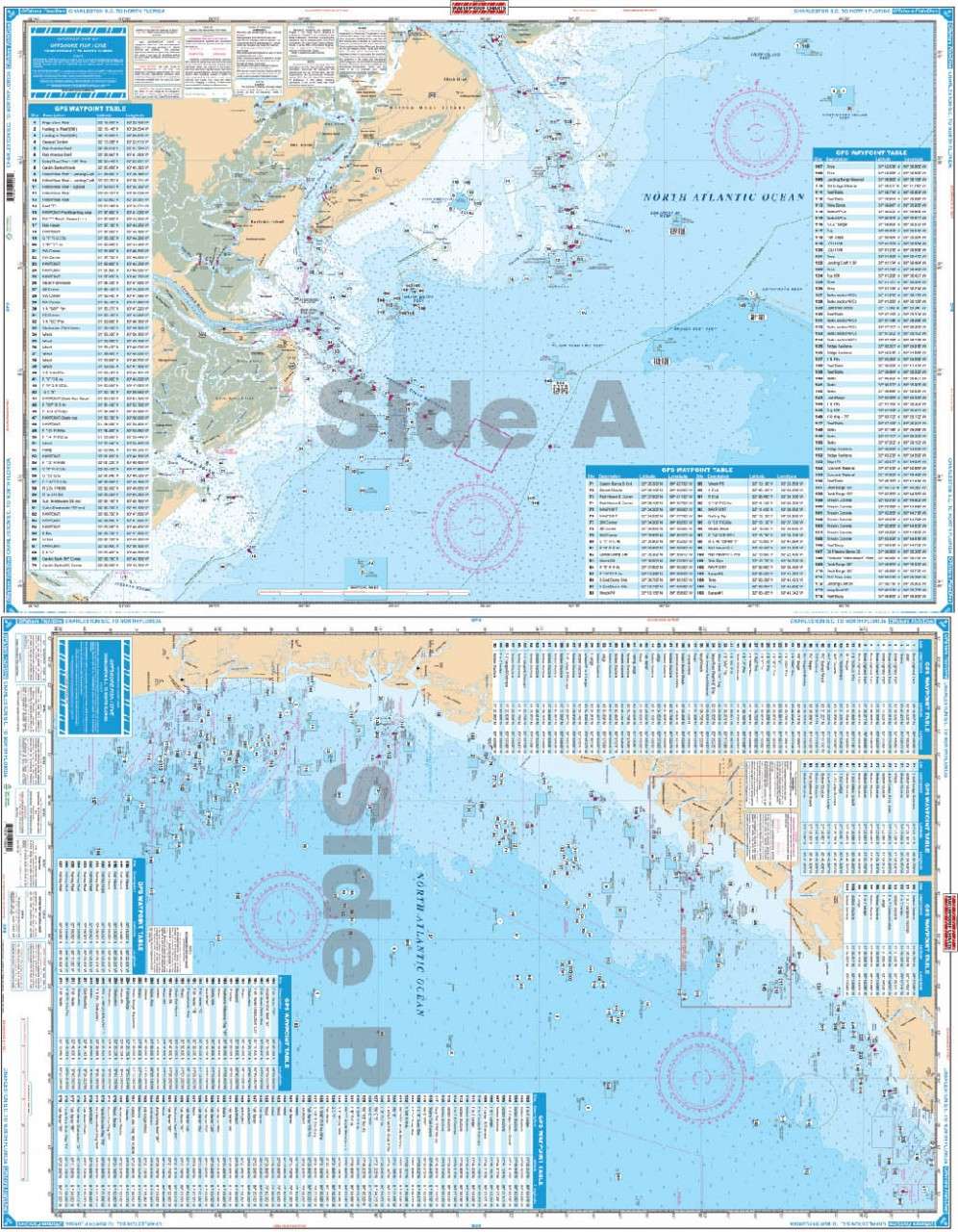
Offshore coverage from the Charleston Light south to 30 miles south of Jacksonville, Florida and offshore approximately 70 miles. Includes the eight "Navy Towers". Large Print and Large Print Place Names make this chart very easy to read.The reverse side covers the coastal area off of Hilton Head and Savannah out to the Hunting Island Reef (60' Depth). A total of 390 GPS coordinates are indexed and plotted for reefs and wrecks, artificial reefs, hardbottom areas, lights, buoys, and fishing and diving areas. Each site is plotted in its exact position so you can see its position relative to other sites, land, harbors, etc. Information from 3 NOAA Charts: 11480, 11509 and 11513. GPS Datum. 25" x 38"
SKU: 120F
Description:
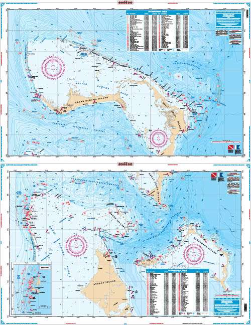
Completely redone in 2011 this chart features fishing and diving information available from no other source. Exceptional bright colors make this chart easy to read and excellent for framing and hanging at home or office. The best Bahamas fishermen contributed to this chart. Deepwater contours surrounding the major islands of the Northern Bahamas with coverage from Walkers Key, Grand Bahama and the Little Bahama Bank to Cherokee Sound, Abaco on the North Side.Also includes coverage from Great Issac, Bimini and Hole in the Wall, Abaco southeast to Chub Cay, Nassau and Eleuthera on the south side. Major deepwater fishing areas for Wahoo, Tuna, Dolphin and Marlin with their LOCAL names and GPS positions. Detailed inset for Bimini with both shallow and deep dive sites and wrecks with several "deep dropping" areas. A total of 129 GPS Waypoints! Information from 4 NOS charts. 1984 GPS Datum. 25" x 38"
SKU: 121F
Description:
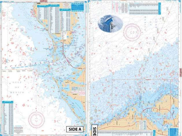
The only chart of this type. Combines 3 NOAA Fishing Maps (now out of print) with a NOAA Bathymetric on the reverse side. Inshore Coverage from Venice south to Sanibel and out to 80'showing bottom quality and featuring 6 different types of bottom conditions: shell, mud, coral, rock, gravel and sand. Each bottom type is colored and identified by GPS coordinates.The reverse side covers further offshore to 180' deep with full bathymetric detail. Plotted and indexed artificial reefs and wrecks and holes on both sides. A total of 270 GPS coordinates for fishing features. GPS Datum. 25" x 38"
SKU: 123F
Description:
Brand new completely redone in 2011 with coverage from Ft. Pierce south to Key Largo and offshore to the West Bahamas. Highlighted are popular trolling areas with their local names which provide the structure for the best deep water fishing including Sailfish Alleys, Swordfish, Haulover and Holy Grounds, The Zoo, Tuna City, and Bimini Blue Marlin Grounds.Over 100 GPS coordinates provide targets for trolling fishermen. The reverse side is coverage from North Miami to Elliot Key with inshore detail and has listings for 70 popular wrecks and reefs, all with GPS coordinates. A total of 170 numbers! If you're fishing for swordfish, dolphin, wahoo, tuna, marlin, sailfish, and/or kingfish in SE Florida, this is the ONE to have. 25" x 38"
Description:
Coverage from Ponce Inlet south to Stuart and out to 60 miles offshore. Derived from 4 different Baythymetric charts showing detailed bottom contour thru the deepest water. Popular fishing grounds are highlighted with their local names and GPS coordinates. Over 160 indexed and plotted coordinates for fishing on the offshore side.The reverse side is more detailed coastal coverage from Ponce Inlet to south of the Port Canaveral channel with additional coordinates for buoys and fishing areas. A total of over 200 coordinates. Information from NOAA chart 11484 and 4 Bathymetric charts. GPS datum. 25" x 38"
SKU: 125F
Description:
Brilliantly colored, this chart employs new graphic features to describe the deepwater fishing and diving opportunities offshore Northeast Florida. The north side covers from the Grand Banks (offshore Darien, Georgia) south to the St. Augustine Inlet and east past the edge of the beautifully defined continental shelf. The south side details the St Augustine Grounds and reefs and continues south past Daytona Beach to south of Ponce Inlet. Both sides have brightly colored areas of live bottom grounds, hundreds of coordinates for GPS for navigation points, wrecks, reefs and ledges. Local names are used to reference grounds, and major fishing and diving hotspots, "The Steeples, The Rolldown, The Ledge, Red Snapper Sink" are described graphically and with pinpoint coordinates. A total of 288 GPS coordinates. Important contours for fishermen are highlighted, the 15 and 21 fathom curves are included with others .If you fish or dive in this area, you will want two; one for the boat and one for your wall! Information from NOAA Chart #11480. GPS Datum. 25" x 38"
SKU: 127F
Description:
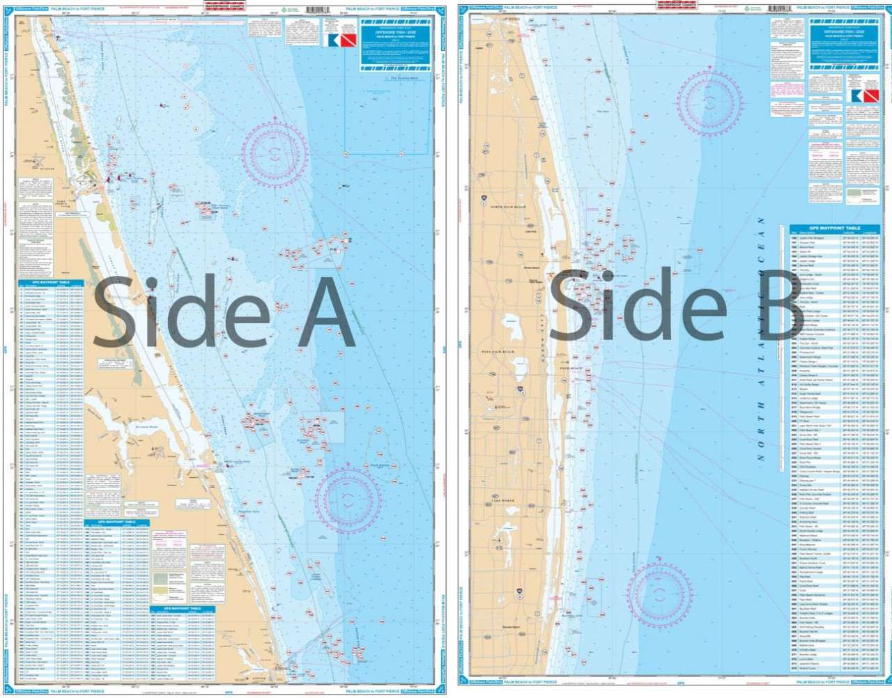
The definitive guide to fishing and diving the offshore structure of the coast from Hutchinson Island south to Boynton Inlet. Entirely new and recompiled for '99 , over 240 fish and dive sites are indexed and plotted with their local names and both their complete GPS coordinates. A new bigger table of coordinates is in large print is very easy to read. Bright colors define shoals, prominent natural fishing areas as well as the "drop off". Enhanced numbers on the 43000 Loran Line are easy to read and local areas "The Loran Tower, The Ranch and the Juno Ball" are clearly marked so that you can listen in and understand where the action is. If you are fishing or diving out of Lake Worth Inlet, Jupiter, Stuart or Ft. Pierce this is the one to have. Computer updated information from 3 government charts:11460, 11466 and 11474.. GPS Datum. 25" x 38"
SKU: 155F
Description:
This unique chart covers the offshore area from the mainland out 70 miles to 210 ft depths. Bathymetric contours and highlighted areas detail coral and holes for fishermen. 197 sets of GPS Coordinates pinpoint these features plus artificial reefs and inlet buoys.The reverse side splices 2 NOAA charts for continuous coverage from Sarasota Point north to Indian Rocks Beach with 210 GPS Coordinates for Fishing Sites. A total f over 400 sets of numbers. Information from 2 NOAA charts: 11412 and 11424. GPS Datum. 25" x 38"
Description:
Offshore coverage from Steinhatchee River south to Anna Maria Island and out to the Florida Middle Grounds (100 miles). Coastal Coverage on reverse side from Port Inglis south to Anclote River. 184 Plotted and Indexed GPS Positions with descriptions for Reefs, Wrecks, Ledges and Markers. Enhanced Contour Lines. Information from 2 NOAA Charts: 11409 & 11400. GPS Datum. 25" x 38"
SKU: 6F
Description:
Coverage from "Bud & Mary's" on Upper Matecumbe Key west to Bahia Honda Key - offshore to the reef (60' curve), and approximately 4 miles into Florida Bay. Great detail of Marathon and Boot Key Harbor. Complete ICW and Hawk Channel Routes. 88 Plotted and Indexed positions for reefs, wrecks, lights, fishing, and diving sites. Information from NOAA 11449. GPS Datum. 25" x 38"
SKU: 7F
Description:
Coverage from the 7-Mile Bridge west to Boca Grande Key and Woman Key (10 miles west of Key West). Offshore to the Reef and north to The Content Keys and Turtlecrawl Bank. West Side is detailed coverage of Key West Area. 80 Plotted and Indexed GPS Positions for reefs, wrecks, lights, fishing and diving sites. Information from 2 NOAA charts: 11441 & 11442.GPS Datum. 25" x 38"
SKU: 8F
Description:
Coverage from Sand Key and the Northwest Channel (west of Key West) west to Rebecca Shoal on the east side. Offshore inset on west side shows passage from Rebecca to the Tortugas. Detailed coverage of the Dry Tortugas on west side with blow up of Tortugas Harbor and Fort Jefferson. 187 Plotted and Indexed GPS Positions for reefs and wrecks, lights, fishing and diving sites. Added color highlights shallow areas and enhanced contour line defines 60' curves. Information from 3 NOAA Charts: 11439, 1438, 11434. GPS Datum. 25" x 38"
SKU: 9F
Description:
Offshore Coverage from Sanibel south to 20 miles south of Key West, east to Marathon and west to 82 degrees 40 minutes (Rebecca Shoal). Reverse Side is Coastal Coverage of Naples south to Pavillion Key offshore to 82 degrees 5 minutes. Details for Naples - Gordon River and Everglades City. A total of 369 Plotted and Indexed GPS Positions for reefs, wrecks, lights, fishing and diving locations. Information from 2 NOAA charts: 11429 and 11420. GPS Datum. 25" x 38"
SKU: 10F
Description:
Offshore coverage from Rebecca Shoal (west of Key West) to North of Key Largo. Shows depths from the reef out to 500 fathoms and sections of the Gulf to north of Cape Sable. Does not show detail inside the reef or in east Florida Bay nor close to the Keys. Bathymetric contours have been added in popular fishing areas and peaks and holes have been highlighted.A total of 200 Plotted and Indexed GPS Positions for reefs and wrecks, fishing areas such as the "Hump", "Woods Wall", and the "Ups and Downs." Information from 2 NOAA Charts: 11434 and 11450. GPS Datum, 25" x 38"
SKU: 14F
Description:
Completely redone in 2011 with coverage from Turkey Point in Biscayne Bay south to Lower Matecumbe Key. Detailed coverage of both Atlantic and Florida Bay sides of the Keys. Complete coverage of Card Sound, Barnes Sound and Blackwater Sound and Pennekamp Coral Reef Park. Complete ICW coverage to Bowlegs Cut.Florida Bay covered only approximately 5 miles north and west of the Keys. (For complete Florida Bay coverage see # 33 or #33E). Highlighted Park Boundary Lines. A total of 88 Plotted and Indexed GPS Positions for Reefs, Wrecks, Lights and Fishing and Diving Locations. Large Print is very easy to read. Information from 4 NOAA charts: 11463, 11449, 11451, & 11462. GPSDatum. 25" x 38
SKU: 15F
Description:
Complete offshore coverage from Tampa Bay south to 50 Miles South of Marco Island. Reverse side is coastal coverage from Englewood south to Ft. Myers Beach with complete depths for Charlotte Harbor, Pine Island Sound, and Matlacha Pass.A total of 369 plotted and indexed GPS Waypoints for reefs and wrecks, lights, and fishing and diving areas. Information from 2 NOAA Charts: 11426 & 11420. 25" x 38"
SKU: 18F
Description:
Covers the area from Port Inglis around the Big Bend just West of Apalachicola to Cape San Blas. 25" x 38"
SKU: 19F
Description:
Coastal coverage from Cape Canaveral south to Jupiter and offshore to a maximum of 32 miles. Large Place Names make towns easy to find. A total of 211 Plotted and Indexed GPS Waypoints for reefs and wrecks, lights, fishing and diving areas. Information from 2 NOAA Charts: 11474 & 11476. 25" x 38"
SKU: 23F
Description:
Coastal coverage from Jupiter south past Palm Beach, Ft. Lauderdale, and Miami to Elliot Key. Detail of South Biscayne Bay from Government Cut to Black Point and Sands Key. Coverage is up to 10 miles offshore and does not include ICW detail north of Government Cut. (see 23 for ICW detail). A total of 280 plotted and indexed GPS Waypoints for reefs, wrecks, lights, buoys, fishing, and diving areas, including the entire Dade-Broward Artificial Reef Program. Information from 2 NOAA Charts: 11465 & 11466. 25" x 38"
SKU: 94F
Description:
Offshore coverage from Dauphin Island, Alabama to Pensacola Beach Florida out 30 plus miles. This chart is a compilation of 3 NOAA charts # 11360, 11376 and 11382.This chart goes up into MOBILE BAY over 21 miles, and offshore over 30 miles. From Daupin Island the chart goes over 55 miles to the South.The chart has over 550 plotted and indexed GPS waypoints for wrecks, reefballs, ledges and artificial reefs, fishing and diving locations. The really unique feature to this Offshore Fishing Chart is that it is LARGE PRINT!!! Meaning it is much easier to see the coordinates of your favorite fishing destination. No one has a chart like this. If you want to enjoy all of the State, County and private fishing locations in this area , you MUST have this Waterproof Offshore Fishing Chart #94F. If you want ORANGE BEACH , Alabama, you want this chart. 25" x 38"
SKU: 95F
Description:
One side has offshore coverage from 10 miles south of Charleston to north of Morehead City and out past the 100 fathom curve. The reverse side details the Cape Fear and Frying Pan Shoals area north past Wrightsville Beach to New Topsail Inlet. Both sides have colored overlays which detail hardgrounds and live bottom areas indexed to GPS coordinates.The offshore side has additional bottom contours for the drop of area between 30 and 100 fathoms, detailing areas such as "The Steeples, "the Georgetown Hole," "Big Rock," and "Sanctuary." A total of 361 GPS Waypoints for wrecks, lights, and fishing sites. Information from 3 NOAA charts: 11536, 11539, 11520. GPS Datum. 25" x 38"
SKU: 99F
Description:
Offshore coverage from the Charleston Light south to 30 miles south of Jacksonville, Florida and offshore approximately 70 miles. Includes the eight "Navy Towers". Large Print and Large Print Place Names make this chart very easy to read.The reverse side covers the coastal area off of Hilton Head and Savannah out to the Hunting Island Reef (60' Depth). A total of 390 GPS coordinates are indexed and plotted for reefs and wrecks, artificial reefs, hardbottom areas, lights, buoys, and fishing and diving areas. Each site is plotted in its exact position so you can see its position relative to other sites, land, harbors, etc. Information from 3 NOAA Charts: 11480, 11509 and 11513. GPS Datum. 25" x 38"
SKU: 120F
Description:
Completely redone in 2011 this chart features fishing and diving information available from no other source. Exceptional bright colors make this chart easy to read and excellent for framing and hanging at home or office. The best Bahamas fishermen contributed to this chart. Deepwater contours surrounding the major islands of the Northern Bahamas with coverage from Walkers Key, Grand Bahama and the Little Bahama Bank to Cherokee Sound, Abaco on the North Side.Also includes coverage from Great Issac, Bimini and Hole in the Wall, Abaco southeast to Chub Cay, Nassau and Eleuthera on the south side. Major deepwater fishing areas for Wahoo, Tuna, Dolphin and Marlin with their LOCAL names and GPS positions. Detailed inset for Bimini with both shallow and deep dive sites and wrecks with several "deep dropping" areas. A total of 129 GPS Waypoints! Information from 4 NOS charts. 1984 GPS Datum. 25" x 38"
SKU: 121F
Description:
The only chart of this type. Combines 3 NOAA Fishing Maps (now out of print) with a NOAA Bathymetric on the reverse side. Inshore Coverage from Venice south to Sanibel and out to 80'showing bottom quality and featuring 6 different types of bottom conditions: shell, mud, coral, rock, gravel and sand. Each bottom type is colored and identified by GPS coordinates.The reverse side covers further offshore to 180' deep with full bathymetric detail. Plotted and indexed artificial reefs and wrecks and holes on both sides. A total of 270 GPS coordinates for fishing features. GPS Datum. 25" x 38"
SKU: 123F
Description:
Brand new completely redone in 2011 with coverage from Ft. Pierce south to Key Largo and offshore to the West Bahamas. Highlighted are popular trolling areas with their local names which provide the structure for the best deep water fishing including Sailfish Alleys, Swordfish, Haulover and Holy Grounds, The Zoo, Tuna City, and Bimini Blue Marlin Grounds.Over 100 GPS coordinates provide targets for trolling fishermen. The reverse side is coverage from North Miami to Elliot Key with inshore detail and has listings for 70 popular wrecks and reefs, all with GPS coordinates. A total of 170 numbers! If you're fishing for swordfish, dolphin, wahoo, tuna, marlin, sailfish, and/or kingfish in SE Florida, this is the ONE to have. 25" x 38"
SKU: 124F
Description:
Coverage from Ponce Inlet south to Stuart and out to 60 miles offshore. Derived from 4 different Baythymetric charts showing detailed bottom contour thru the deepest water. Popular fishing grounds are highlighted with their local names and GPS coordinates. Over 160 indexed and plotted coordinates for fishing on the offshore side.The reverse side is more detailed coastal coverage from Ponce Inlet to south of the Port Canaveral channel with additional coordinates for buoys and fishing areas. A total of over 200 coordinates. Information from NOAA chart 11484 and 4 Bathymetric charts. GPS datum. 25" x 38"
SKU: 125F
Description:
Brilliantly colored, this chart employs new graphic features to describe the deepwater fishing and diving opportunities offshore Northeast Florida. The north side covers from the Grand Banks (offshore Darien, Georgia) south to the St. Augustine Inlet and east past the edge of the beautifully defined continental shelf. The south side details the St Augustine Grounds and reefs and continues south past Daytona Beach to south of Ponce Inlet. Both sides have brightly colored areas of live bottom grounds, hundreds of coordinates for GPS for navigation points, wrecks, reefs and ledges. Local names are used to reference grounds, and major fishing and diving hotspots, "The Steeples, The Rolldown, The Ledge, Red Snapper Sink" are described graphically and with pinpoint coordinates. A total of 288 GPS coordinates. Important contours for fishermen are highlighted, the 15 and 21 fathom curves are included with others .If you fish or dive in this area, you will want two; one for the boat and one for your wall! Information from NOAA Chart #11480. GPS Datum. 25" x 38"
SKU: 127F
Description:
The definitive guide to fishing and diving the offshore structure of the coast from Hutchinson Island south to Boynton Inlet. Entirely new and recompiled for '99 , over 240 fish and dive sites are indexed and plotted with their local names and both their complete GPS coordinates. A new bigger table of coordinates is in large print is very easy to read. Bright colors define shoals, prominent natural fishing areas as well as the "drop off". Enhanced numbers on the 43000 Loran Line are easy to read and local areas "The Loran Tower, The Ranch and the Juno Ball" are clearly marked so that you can listen in and understand where the action is. If you are fishing or diving out of Lake Worth Inlet, Jupiter, Stuart or Ft. Pierce this is the one to have. Computer updated information from 3 government charts:11460, 11466 and 11474.. GPS Datum. 25" x 38"
SKU: 155F
Description:
This unique chart covers the offshore area from the mainland out 70 miles to 210 ft depths. Bathymetric contours and highlighted areas detail coral and holes for fishermen. 197 sets of GPS Coordinates pinpoint these features plus artificial reefs and inlet buoys.The reverse side splices 2 NOAA charts for continuous coverage from Sarasota Point north to Indian Rocks Beach with 210 GPS Coordinates for Fishing Sites. A total f over 400 sets of numbers. Information from 2 NOAA charts: 11412 and 11424. GPS Datum. 25" x 38"
Share